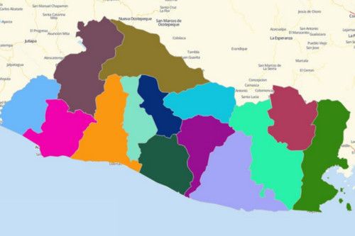
EL SALVADOR DEPARTMENTS
- Territory Guide
- EL SALVADOR DEPARTMENTS
Seamlessly discover patterns and trends when you start creating a map of El Salvador departments. It is the best way to view how your business fares in each department. With Mapline, we’ll show you how easy it is to create a territory map and maximize the uses of it to your advantage.
Don’t know, we’e here to guide you from start to finish.
A CLOSER LOOK AT EL SALVADOR DEPARTMENTS
You can easily create a map of El Salvador departments using Mapline. Known as the “Tom Thumb of the Americas,” El Salvador is the smallest and the most densely populated country in the region of Central America. The country’s economy lies in agriculture. Coffee is their most exported product. However, in the turn of the 20th century, it slowly embarked on different economic structures, particularly trade and manufacturing.
Using Mapline, you can easily create a map of El Salvador departments. El Salvador is divided into 14 departments headed by governors. These departments function as a county. They are divided into 263 municipalities which are headed by mayors.
ADD EL SALVADOR DEPARTMENTS TO MAP
Do you want to monitor and boost your business’ progress? Then be on top of it as you add department territories to your map.
A map with department boundaries makes a great visualization to pinpoint insights vital in creating new marketing strategies, optimizing routes, and identifying growth opportunities.
Add territories by clicking the ADD button located at the upper left side of your map. Search for MAPLINE’S REPOSITORY. Instead of scrolling down to find the terriotry you’re looking for, it’s much easier to just type EL SALVADOR and choose EL SALVADOR DEPARTMENTS.
Now that you’ve located the right territory, there’s just one step remaining and you’re good to go.


Pro Tip: ONLY INCLUDE A PRO TIP IF THERE’S USEFUL OR VITAL INFORMATION USERS NEED TO KNOW.
CHOOSE DEPARTMENT COLORS
Because we want your mapping experience enjoyable, Mapline designed a way to make your territory analysis more thrilling by adding colors to your territories.
When the department boundaries are color-coded, they bring out the uniqueness in each territory. So whether you want to understand more on community planning, economic development, or health and human services, color styles will never let you down.
Once you’ve selected the color style that’s fit for your analysis, click OK and your map of El Salvador departments is ready to be used.

GET NEW TERRITORY INSIGHTS
That’s how easy it is to create a map of El Salvador Departments! Once you have your map, you can create a map of Excel spreadsheet locations to overlay on top. Mapline also makes it simple to see summary information about the locations inside each department just by clicking on them! Sign up now to create a map of El Salvador Departments.


