IRELAND PROVINCES
- Territory Guide
- IRELAND PROVINCES
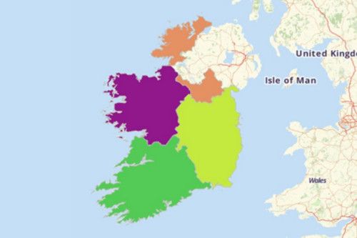
You can now create a map of Ireland provinces using Mapline.
A CLOSER LOOK AT IRELAND PROVINCES
Ireland is divided into four provinces: Connacht, Leinster, Munster and Ulster. The Irish word “cúige” for provincial division literally means “fifth part.” Historically the country had five provinces, including a fifth called Meath. Today, parts of Meath are assigned to Leinster and Ulster. The Ireland provinces have no administrative or political purposes; rather, they function as cultural and historical entities.
ADD IRELAND PROVINCES TO MAP
Map making is easy with Mapline—whether you’re planning a business trip to Ireland or uncovering insights about sales and marketing territories. To create a map of Ireland and visually showcase each province, follow these simple steps:
Use this guide to add territories to your map.
Click the ADD button located at the sidebar. Then, in the search bar, type IRELAND and choose PROVINCES.


Pro Tip: ONLY INCLUDE A PRO TIP IF THERE’S USEFUL OR VITAL INFORMATION USERS NEED TO KNOW.
CHOOSE PROVINCIAL COLORS
The more exciting part is that the power to assign colors to your territories is now in your hands.
Just select the type of territory colors you need, and click OK. And there you go! You just created your very own territory map showing all the provinces in Ireland.

GET NEW TERRITORY INSIGHTS
That’s how easy it is to create a map of Ireland provinces! Ready to create your first Mapline map? Find more mapping options here:


