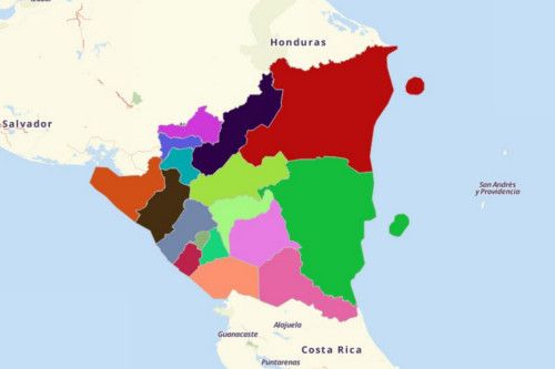
NICARAGUA DEPARTMENTS
- Territory Guide
- NICARAGUA DEPARTMENTS
Align and balance your territories with an overlay of the departments of Nicaragua to your map. This is proven to be more helpful especially when you are focusing on a more localized territories. Instead of using larger territories use department boundaries to focus on smaller areas to easily target the connections and proximity. One such territory is the Nicaragua Departments
Let’s start now!
A CLOSER LOOK AT NICARAGUA DEPARTMENTS
Also called the “Land of Lakes and Volcanoes,” Nicaragua boasts its very own Lake Nicaragua – the largest lake in Central America. The country is also the largest country in Central America.
Using Mapline, you can easily create a Departments of Nicaragua map. Nicaragua consists of 15 departments and 2 autonomous regions which serve as autonomous communities – the North Caribbean Coast Autonomous Region (RACCN) and South Caribbean Coast Autonomous Region (RACCS).
ADD DEPARTMENTS OF NICARAGUA TO MAP
To be effective in managing territories, start by adding a territory to your map. This leads to a seamless balancing and aligning of territories for a more successful territory management.
It’s a good thing that Mapline’s repository is equipped with a wide array of territories available to add to your map. To help save you time, use the search bar to type NICARAGUA and it will show you all the territory boundaries for it. Choose DEPARTMENTS
As simple as that and you’re on to the next step to achieve success in territory management.


Pro Tip: Mapline provides territories for Nicaragua. Choose from department and municipality boundaries.
CHOOSE DEPARTMENT COLORS
Colors add beauty to life. The same goes in territory management. Just by adding colors to your territories, you get to really understand each territory boundary.
Adding colors to your map is not just aesthetically pleasant. What’s even more awesome is that it affect your analysis because it helps to quickly capture ideas that are valuable. These ideas in turn can be used to optimize and improve sales territory alignment.
In Mapline, choose from 4 color style options – random, uniform, custom color, and heat map. Choosing any of them is very advantageous to help you refine your territory planning and management. Choose what’s best for you.

GET NEW TERRITORY INSIGHTS
That’s how easy it is to create a Departments of Nicaragua map! Once you have your map, you can create a map of Excel spreadsheet locations to overlay on top. Mapline also makes it simple to see summary information about the locations inside each department just by clicking on them! Sign up now to create a Departments of Nicaragua map.


