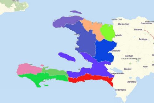
HAITI DEPARTMENTS
- Territory Guide
- HAITI DEPARTMENTS
[INTRO TEXT- THIS IS THE SAME INTRO WE’VE BEEN USING FOR EVERY ARTICLE, DO NOT CHANGE]
A CLOSER LOOK AT HAITI DEPARTMENTS
You can easily create a map of Haiti departments using Mapline. The Republic of Haiti is located in the Caribbean. Its neighboring country is the Dominican Republic. Haiti covers an estimated land area of 27,750 square kilometers. It is the 3rd most populous country in the Caribbean.
Using Mapline, you can easily create a map of Haiti departments. Haiti is divided into 10 departments which are further divided into 41 arrondissements and sub-divided into 133 communes as 2nd and 3rd level administrative divisions respectively. Communes are still divided into 570 communal sections. Artibonite is the largest department in size while the department of Ouest is the most populous.
ADD HAITI DEPARTMENTS TO MAP
[INSTRUCTIONAL TEXT HERE]


Pro Tip: ONLY INCLUDE A PRO TIP IF THERE’S USEFUL OR VITAL INFORMATION USERS NEED TO KNOW.
CHOOSE DEPARTMENT COLORS
[PARAGRAPH HERE]

GET NEW TERRITORY INSIGHTS
That’s how easy it is to create a map showing all departments of Haiti! Once you have your map, you can create a map of Excel spreadsheet locations to overlay on top. Mapline also makes it simple to see summary information about the locations inside each department just by clicking on them! Sign up now to create a map of Haiti departments.


