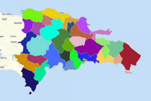
DOMINICAN REPUBLIC PROVINCES
- Territory Guide
- DOMINICAN REPUBLIC PROVINCES
Be in control with the ins and outs of your business operation. See it visually as you create a map of Dominican Republic Provinces.
Identify opportunities in each province boundary. Worry no more cause we’ll help you maximize the uses of your territory map.
A CLOSER LOOK AT DOMINICAN REPUBLIC PROVINCES
You can easily create a map of Dominican Republic provinces using Mapline. Because the Dominican Republic is strategically located in the Caribbean, it is believed to be the country with the largest economy in that region. It is also the 9th largest economy in Latin America. Its major economies include agriculture, mining, and services.
Using Mapline, you can easily create a map of Dominican Republic provinces. The country is divided into 31 provinces headed by governors. Santo Domingo, the nation’s capital, has its own national district. The provinces are further divided into 124 municipal districts headed by elected mayors. Each province has 2 or more municipalities.
ADD DOMINICAN REPUBLIC PROVINCES TO MAP
This serves as your guide when adding territories.
Once added, you can start a thorough territroy analysis and find insights from location awareness.


Pro Tip: Mapline Repository provides both the province and municipality territories.
CHOOSE PROVINCE COLORS
Next step to take is to add colors to the provincial boundaries. Detect patterns and trends easily. Highlight valuable ideas as you create or alter plans for business operations.
When we say add colors, we don’t mean just sprinkle with colors. In Mapline, it means choosing from different color styles – random, uniform, custom color, or heat map colors.
Bring in more impact to your analysis as you put colors to your map.

GET NEW TERRITORY INSIGHTS
That’s how easy it is to create a map of Dominican Republic provinces! Once you have your map, you can create a map of Excel spreadsheet locations to overlay on top. Mapline also makes it simple to see summary information about the locations inside each province just by clicking on them! Sign up now to create a map of Dominican Republic provinces.


