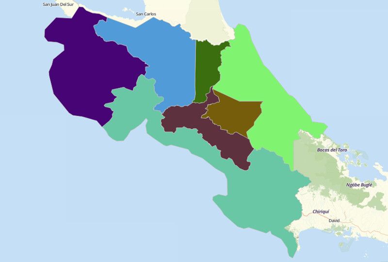
COSTA RICA PROVINCES
- Territory Guide
- COSTA RICA PROVINCES
Business owners and decision makers alike have one concern in common – to expand. The answer to that is simply to create a map of Costa Rica provinces.
Let’s find out how a provincial-level analysis is a great tool to tell you where and how to expand your business.
A CLOSER LOOK AT COSTA RICA PROVINCES
The name of this Central American country literally means “rich coast.” True to its name, Costa Rica is rich in natural resources especially its fertile land which makes agriculture the major industry. It shares its borders with Nicaragua, Panama, and Ecuador.
Using Mapline, you can easily create a map of Costa Rica provinces. Costa Rica is divided into 7 provinces which are further divided into 81 cantons and sub-divided into 473 districts. The provinces are:
- Alajuela – composed of 15 cantons divided into 111 districts
- Cartago – one of the smallest province with 8 cantons
- Guanacaste – the most sparsely populated province subdivided into 11 cantons
- Heredia – with 10 cantons and 47 districts
- Limón – the most culturally diverse province with 6 cantons
- Puntarenas -with 11 cantons plus an island called Isla del Coco
- San José – the provincial capital with 20 cantons
ADD COST RICA PROVINCES TO MAP
When you add province boundaries, you’ll be able to view how your stores are performing. You can even view how your competitors are faring in each province. For that, it is highly suggested to add the province territory on your map.To make sure you choose the right territory from Mapline’s Repository, type COSTA RICA in the search bar, and select COSTA RICA PROVINCES.
How cool is that?
Learn to make the best use of the province boundaries. Together with your data, analyzing patterns and relationships will take only a few minutes – or even in just a few seconds! That usually takes hours and even days when your data is just hidden in rows and columns of spreadsheets.


Pro Tip: ONLY INCLUDE A PRO TIP IF THERE’S USEFUL OR VITAL INFORMATION USERS NEED TO KNOW.
CHOOSE PROVINCIAL COLORS
What will make you super excited to use your map of Costa Rica provinces is when you add colors to it .
Just by adding colors, you get to find ideas on how to grow your business thereby making roonms for expansion. With colors, geographical insights are easily detected and can be readily used for decision making.
Go ahead, choose to fill colors with the given selections: random colors, custom-colored from spreadsheet, heat map colors, or uniform colors.

GET NEW TERRITORY INSIGHTS
That’s how easy it is to create a map of Costa Rica provinces! Once you have your map, you can create a map of Excel spreadsheet locations to overlay on top. Mapline also makes it simple to see summary information about the locations inside each province just by clicking on them! Sign up now to create a map of Costa Rica provinces.


