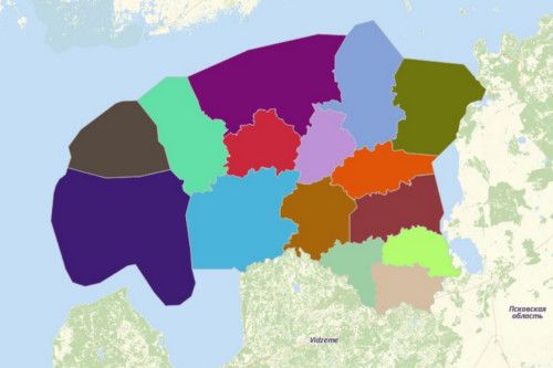
ESTONIA COUNTIES
- Territory Guide
- ESTONIA COUNTIES
Add Estonia counties to your map and discover the latest trends to help you craft a strong brand presence and marketing approach.
A detailed territory map of Estonia counties is a game-changer for your brand. It allows you to analyze potential market areas and make informed decisions for your next business plans.
Unleash the power of location data as you create your territory map now!
A CLOSER LOOK AT ESTONIA COUNTIES
You can easily create a map of Estonia counties using Mapline. The Republic of Estonia can be found in the Northern Europe. It is bordered Finland, Latvia, Russia and Sweden. Aside from its mainland, the country is made up of 2,222 islands and islets in the Baltic Sea.
Using Mapline, you can easily create a map of Estonia counties. Counties are the 1st level administrative subdivisions, each headed by appointed governor. There are 15 counties in Estonia – 13 on the mainland and 2 on the islands. These counties are further divided into 213 municipalities. Estonia has 2 types of municipalities: Urban (towns) and Rural (parishes).
ADD ESTONIA COUNTIES TO MAP
Get ready to view limitless possibilities when you add Estonia counties to your map. Analyze county trends, optimize routes, craft location-intelligent business plans, and so much more!
First, click the ADD button located at the left side of your map. Choose TERRITORIES and FROM MAPLINE’s REPOSITORY to add territory. Use the search bar to save time. Then type ESTONIA and choose ESTONIA COUNTIES.
Now you’re halfway there. Just one last step to complete the process.


Pro Tip: Aside from the county boundaries, Mapline’s Repository also has the municipality and settlement unit boundareis for Estonia.
CHOOSE COUNTY COLORS
Make your territories more pleasant to look at with custom colors. But more than making your map look attractive, adding colors, speak volumes about your data.
Use static colors to represent target locations for expansion, where your customers are residing, or popular destinations. You can also leverage dynamic styling to create a heat map that automatically updates as you update your data.
That’s the power of custom territory styling! Configure your settings, click OK, and your map is ready to view and use.

GET NEW TERRITORY INSIGHTS
That’s how easy it is to create a map showing all the counties of Estonia! Once you have your map, you can create a map of Excel spreadsheet locations to overlay on top. Mapline also makes it simple to see summary information about the locations inside each zip cod just by clicking on them! Sign up now to create a map of Estonia counties.


