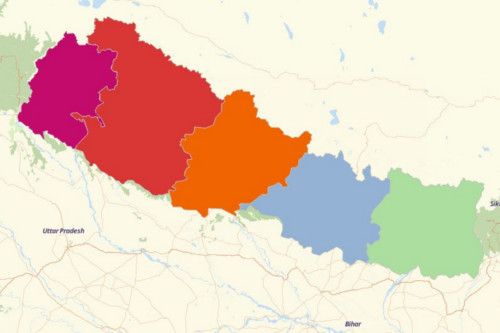
NEPAL REGIONS
- Territory Guide
- NEPAL REGIONS
Maximize your business planning as you create a map of Nepal regions. After all, it only takes a few seconds. Once done, you can add your data and see connections between your data and territory boundaries.
How else you can benefit from this map? Let’s find out.
A CLOSER LOOK AT NEPAL REGIONS
You can easily create a map of Nepal regions using Mapline. Rich in ancient culture, the Federal Democratic Republic of Nepal is divided into 5 development regions which are further divided into 14 administrative zones and 75 districts. The regions of Nepal are:
- Eastern Development Region = home of 3 zones: Sagarmatha, Koshi, and Mechi
- Central Development Region = home of 3 zones: Bagmati, Narayani, and Janakpur
- Mid-Western Development Region = home of 3 zones: Karnali, Bheri, and Rapti
- Western Development Region = home of 3 zones: Dhawalagiri, Gandaki, and Lumbini
- Far-Western Development Region = home of 2 zones: Mahakali and Seti
ADD NEPAL REGIONS TO MAP
If you’re a business owner who needs to track down the sales performances of your stores scattered in different regions, then the best way to do that is to make a region-level analysis. Doing so will open the gates for your to identify new insights that may be carefully hidden when no territory boundaries are plotted on your map.
To start off, just add territories FROM MAPLINE’S REPOSITORY.
In the search bar, type NEPAL and select NEPAL REGIONS.


Pro Tip: Aside from the region boundaries, Mapline’s Repository offers other territories for Nepal like vilalges, districts, and zones.
CHOOSE REGION COLORS
You’re almost not done. Just one more step… See your territories in a different perspective as you add colors to them.
Assign colors to your territories make your map aesthetically attractive, But more than that, it helps intensify your analysis and capture insights that are relevant to your decision making.
Whether you pick random colors, or uniform color, or heat map colors, you’ll never go wrong with assigning colors to your territories.

GET NEW TERRITORY INSIGHTS
That’s how easy it is to create a map of Nepal regions! Once you have your map, you can create a map of Excel spreadsheet locations to overlay on top. Mapline also makes it simple to see summary information about the locations inside each region just by clicking on them! Sign up now to create a map of Nepal regions.


