If you’ve used Google Maps to navigate to a new city, find the distance between two points or create a map for a presentation, you’re not alone. Google Maps is one of the most popular mapping applications—and for good reason. The tech company’s mapping solution is available for online browsers and pre-installed on most mobile phones, making it a convenient choice for users.
PLT4M is a digital training solution designed by two former Division 1 athletes to give high school student-athletes access to fundamental, quality exercises. Its training curricula allow coaches and teachers to focus on students involved in all types of sports—from football and lacrosse to volleyball, track and more. Teachers and coaches can help students leverage PLT4M for sport-related training, personal fitness plans and exercise goals.
GIS mapping is a powerful technology, and many college and university professors are taking note of its utility as a classroom learning tool. While its uses vary across majors and degree concentrations, GIS provides all students with a range of skillsets, such as problem solving and database management, as well as map creation, data accuracy, and the ability to adapt to technology in ever-changing workforces. How does this translate for students in the classroom? Here are three real-world examples of how college professors use GIS technology.
1. Honing Skills for Further Research
Professors at Dickinson College pair GIS with academics to teach students to think about problems in a spatial context. They encourage students to ask:
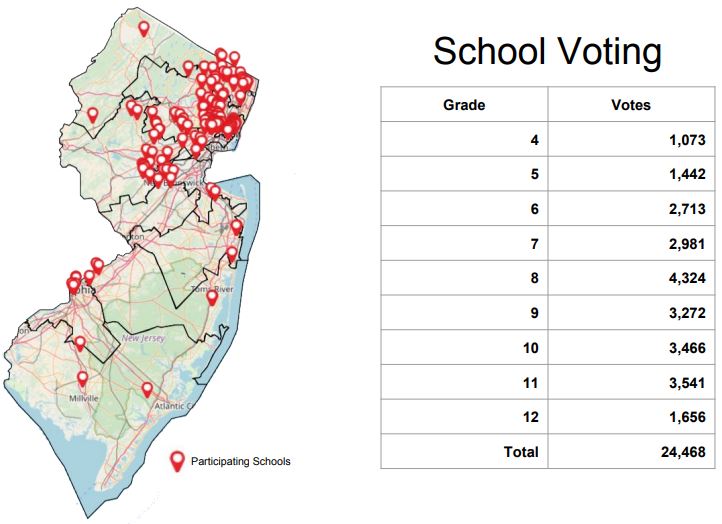
At Mapline, we’ve collaborated with New Jersey teachers and schools to help students vote in elections and experience the democratic process. Our interactive mapping software for schools makes it easy for teachers to register their students’ participation and analyze the results once all votes have been counted. For most students, the New Jersey mock election is the first opportunity they’ll have to cast a vote.
Daily news platform YourNews brings local news online to audiences across the United States. By partnering with network affiliates and advertisers, the company serves a nationwide audience by Zip Code. The website—an aggregate of city, county, state, regional and international news stories—aims to provide accessible local news to as many readers as possible amid declining print newspaper readership. To achieve his goal, Sam Anthony, CEO and president of YourNews, needed to find affiliates to help serve news, as well as advertisers to promote it. When a colleague recommended he try a geographic network map, Anthony questioned the idea. Did he need to plot points on a map? How would creating a network map pay off for his business in the end?
Planning routes by hand has never been an easy task. Whether your priority is managing a successful sales team or scheduling a large fleet, manual planning can lead to route inaccuracies. And inaccuracies mean unhappy customers, decreased lead generation, and costly delivery blunders. The solution? Powerful automated route planning not only creates efficient routes in just minutes but also helps identify your best opportunities for growth. Check out three ways route planning software leads to business success.
Route Planning Leads to Increased Sales
Your sales reps’ wish list likely includes faster routes and shorter drive times. With route planning, simply draw a custom shape around a sales territory. Then, the mapping application creates a personalized route with pins, based on start and end points. Route planning software allows sales reps to visualize their daily schedule on a map, decrease drive time, and ultimately add more appointments to their calendar. And when your reps have more time to spend in their territory, they sell faster and smarter.


 PLT4M is a digital training solution designed by two former Division 1 athletes to give high school student-athletes access to fundamental, quality exercises. Its training curricula allow coaches and teachers to focus on students involved in all types of sports—from football and lacrosse to volleyball, track and more. Teachers and coaches can help students leverage

 At Mapline, we’ve collaborated with New Jersey teachers and schools to help students vote in elections and experience the democratic process. Our
